Key takeaways
- Time-lapse 3D modeling enables 4D monitoring, capturing both spatial and temporal changes with millimeter accuracy.
- The photogrammetry software market is booming, projected to grow from $1689.5 USD million in 2025 to $5110.8 USD million by 2033
- Multiple industries benefit, from geological monitoring to construction progress tracking and cultural heritage preservation.
- Drone integration is accelerating adoption, with the drone photogrammetry software market being valued at $2.6 USD billion in 2023, with a projected growth to $8.7 billion by 2033
- AI-enhanced software is becoming used in 3D time-lapse and photogrammetry to speed up processing and reduce errors.
TL;DR
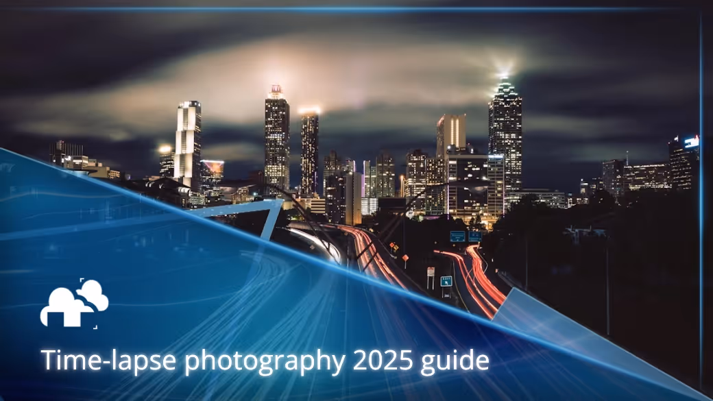
Time-lapse photography in 3D is changing how we capture and understand the world. By combining sequential image capture with 3D reconstruction, time-lapse techniques create 4D models that reveal change across time. These can be built from real-world photographs or simulated entirely in 3D software. Applications range from construction and geological monitoring to heritage preservation and education. With drones making capture easier and AI accelerating workflows, 3D time-lapse modeling is becoming an essential tool for science, industry, and storytelling.
Why time-lapses in 3D matter
Time-lapse has always fascinated viewers by turning hours, days, or years into seconds of footage. But when combined with 3D modeling, it becomes much more than a cinematic effect. A 3D time-lapse allows us to not only watch change unfold but also measure, analyze, and interact with it in a spatially accurate way. Instead of passively watching a flower bloom or a building rise, you can rotate the scene, zoom in, and study the transformation from any angle.
“Thanks to these techniques, we now have virtual reconstructions of all the Trinchera sites, so they can be studied as though they had never been excavated" - Researcher Benito Calvo on using 4D reconstruction
What makes a 3D time-lapse different from a normal time-lapse?
A traditional time-lapse video compresses time into a sequence of flat frames. It shows change but locks the viewer into a single perspective. A 3D time-lapse, however, reconstructs each interval as a full 3D dataset. This means the viewer can move around in space and watch the transformation unfold in depth. For example, you can see this effect in this video provided by yoshi2233, where multiple captures are stitched together into a time-lapse reconstruction:
This difference is what makes 3D time-lapse so powerful: it is not just a visual trick, but a new way of experiencing and analyzing temporal change.
Types of 3D time-lapses
Real-world capture
Real-world 3D time-lapses are created using cameras, drones, or scanners that repeatedly capture the same subject over days, weeks, or even years. The images are reconstructed into 3D models at intervals, which are then linked into a sequence. This approach is widely used in construction monitoring, geological surveys, and ecological studies. In this video by Helios Visions, we can see an example of this in which real-world capturing was used to create a 3D model:
Simulated time-lapses
Not all time-lapses need to be recorded from reality. Simulated time-lapses are created inside 3D software, where changes such as sunlight, weather, growth, or construction are animated over time. These are invaluable in architecture, urban design, and education, where predicted changes need to be visualized before they happen. For example, this fake pumpkin time-lapse by Chris R shows how software like Blender can mimic natural processes:
Hybrid approaches
Some projects combine real-world and simulated methods. A city planner may capture a real 3D time-lapse of urban growth and then extend it with simulations of how infrastructure will expand in the next decade. Heritage projects may document real decay and overlay models predicting how monuments will look after restoration.
How 3D time-lapses are made
Beyond fake time-lapse simulations involve different steps in 3D time-lapses such as image and data capturing, reconstruction, and data alignment:
Image and data capture
The foundation of a real-world 3D time-lapse is consistent image capture. This might involve ground cameras on tripods, aerial drones flying repeat paths, or laser scanners documenting environments. Intervalometers or programmed drone missions ensure consistent timing.
Reconstruction techniques
Captured images can be turned into 3D using methods like structure-from-motion photogrammetry or laser scanning. AI-enhanced software is becoming increasingly used in 3D time-lapse and photogrammetry workflows to speed up processing and reduce errors.
Data alignment and temporal stitching
Once models are generated for each interval, they are aligned and stitched into a continuous sequence. The result is not a single static scan but a dataset that evolves through time, showing measurable changes with high precision.
Why 3D time-lapses are powerful
Seeing change that would otherwise be invisible
Processes like glacier retreat, plant growth, or soil erosion often happen too slowly to observe directly. A 3D time-lapse makes these transformations visible, compressing years of change into seconds while retaining spatial accuracy.
Turning data into stories
Numbers and charts are informative, but time-lapses communicate visually in ways that anyone can understand. A 4D reconstruction can show investors how a skyscraper grew, demonstrate conservation challenges to the public, or bring scientific data to life in the classroom.
Measuring change with precision
Beyond visuals, 3D time-lapses provide hard data. Millimeter-level accuracy makes it possible to quantify shifts in terrain, measure building progress, or analyze conservation results with scientific rigor.
Industries transforming with 3D time-lapses
Different industries are now adapting 3D time-lapses, with the photogrammetry software market booming, projected to grow from $1689.5 USD million in 2025 to $5110.8 USD million by 2033 (Global Growth Insights, 2025)
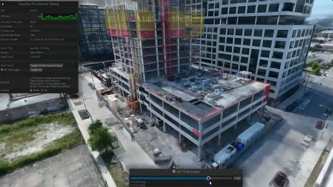
Construction and infrastructure
Time-lapse 3D models serve as dynamic progress reports. Instead of flat photos, managers can explore evolving 3D datasets that reveal how scaffolding, steelwork, or roads appeared at each stage. This improves transparency, prevents disputes, and helps forecast delays. Large-scale projects like stadiums, highways, and bridges increasingly depend on this technology for both internal tracking and stakeholder communication. For those in archviz, it’s also possible to simulate fake time-lapses in 3D to showcase the architecture and design in different lighting conditions or just as an added visual flare, as we can see in this time-lapse tutorial by Decoded:
Environmental and geological studies
Natural environments are in constant motion. Rivers shift channels, glaciers retreat, deserts expand, and forests regenerate. 3D time-lapses can potentially capture these processes in detail, complementing climate models with tangible visual evidence. Agriculture also benefits, as entire growing seasons can be compressed into sequences that reveal soil changes, irrigation effects, and crop development. This timelapse example by Google Earth, for example, can inspire the use of image capturing and shows the potential of how integrating 3D or 4D time-lapses for environmental studies and reports can be beneficial.
For a more real-world example for environments, you may refer to the real world examples section.
Cultural heritage and archaeology
Historic monuments are constantly shaped by weather and pollution. Traditional scans preserve a single state, but 3D time-lapses show ongoing erosion and the effects of conservation. Archaeologists use them to document excavation progress, watching layers of soil and artifacts disappear over time. This can also apply to historical landmarks or cities, such as this 3D animation time-lapse simulation of Pompeii by ZERO ONE:
Education, art, and media
Beyond science and industry, 3D time-lapses are becoming creative tools. Artists use them to animate imagined histories of cities or landscapes. Educators simulate climate impacts to make lessons more engaging. In film and gaming, time-lapse effects are integrated into virtual worlds to create immersive storytelling. In the context of film-making, here is how time-lapses are integrated, as seen in this video by StudioBinder:
Tools and workflows for creating 3D time-lapses
Cameras and drones
Simple experiments can be done with smartphones, but professional projects benefit from DSLR or mirrorless cameras. Intervalometers automate capture, while drones extend coverage to large sites by maintaining consistent aerial paths. Drone integration is also accelerating in adoption, with the drone photogrammetry software market being valued at $2.6 USD billion in 2023, with a projected growth to $8.7 billion by 2033 (Data Horizon Research).
Software for reconstruction
Programs like Agisoft Metashape and Pix4D are great for creating 3D models from captured images and drone mapping. With the fast-growing industry of tech, it is also possible to see new AI-powered solutions in the near future that make these workflows faster and more accessible by doing tasks such as automating alignment and correcting lighting variations.
3D animation software for simulations
For simulated or hybrid time-lapses, tools like Blender, Maya, and Houdini are widely used. These programs allow artists and professionals to animate growth, construction, erosion, and lighting changes in ways that mimic real-world transformations.
Challenges in building 3D time-lapses
Stability and consistency
Even minor shifts in camera position can ruin alignment across time. Fixed tripods, robotic mounts, and drone flight automation help maintain accuracy.
Lighting and weather changes
Clouds, shadows, and seasonal light differences can confuse reconstruction algorithms. Consistent exposure settings and temporal filtering are necessary to maintain clarity.
Processing and storage
High-resolution 3D time-lapse projects can produce datasets in the hundreds of gigabytes, and in some cases terabytes. These often require powerful workstations or cloud platforms to manage, though AI-driven optimization can lighten some parts of the load such as compressing data and automating parts of the workflow. However, strong hardware is still essential for large projects.
Real-world examples
University of Washington’s 3D time-lapse project
Researchers at the University of Washington developed methods to build 3D time-lapse sequences from years of Internet photographs of landmarks and natural scenes. By aligning thousands of uncontrolled, crowdsourced images taken under different conditions, they produced time-lapses, showing how skylines and landscapes evolved over time. Their work demonstrated that even messy online photo collections can be transformed into valuable temporal reconstructions.
Helheim glacier 3D time-lapse
Adam LeWinter’s team captured true 3D time-lapse data at Helheim Glacier by repeatedly scanning the terminus with a long-range terrestrial LiDAR, producing dense point clouds at set intervals . The sequences revealed meter-per-hour ice motion, tidal “bobbing,” and calving dynamics across kilometers of ice, enabling quantitative measurements rather than just visual change.
The future of 3D time-lapse modeling
There are numerous possibilities for the future for 3D time-lapses that we can all keep our eyes peeled for. For one, advances in sensors and processing are making it possible to create live 3D or 4D time-lapses that update continuously, effectively turning cameras into real-time monitoring systems. Urban planners are also beginning to integrate these evolving datasets into digital twin platforms, allowing them to simulate infrastructure development, monitor risks such as flooding, and improve resilience planning. Time-lapse 3D data is also expected to play a major role in climate visualization, helping researchers illustrate the effects of sea-level rise, drought, and ecosystem change by pairing reconstructions with predictive models. Beyond science and planning, immersive technologies like VR and AR will allow people to step inside time-lapses, walking through environments as they evolve.
Register Now and Get $50 FREE Credits!